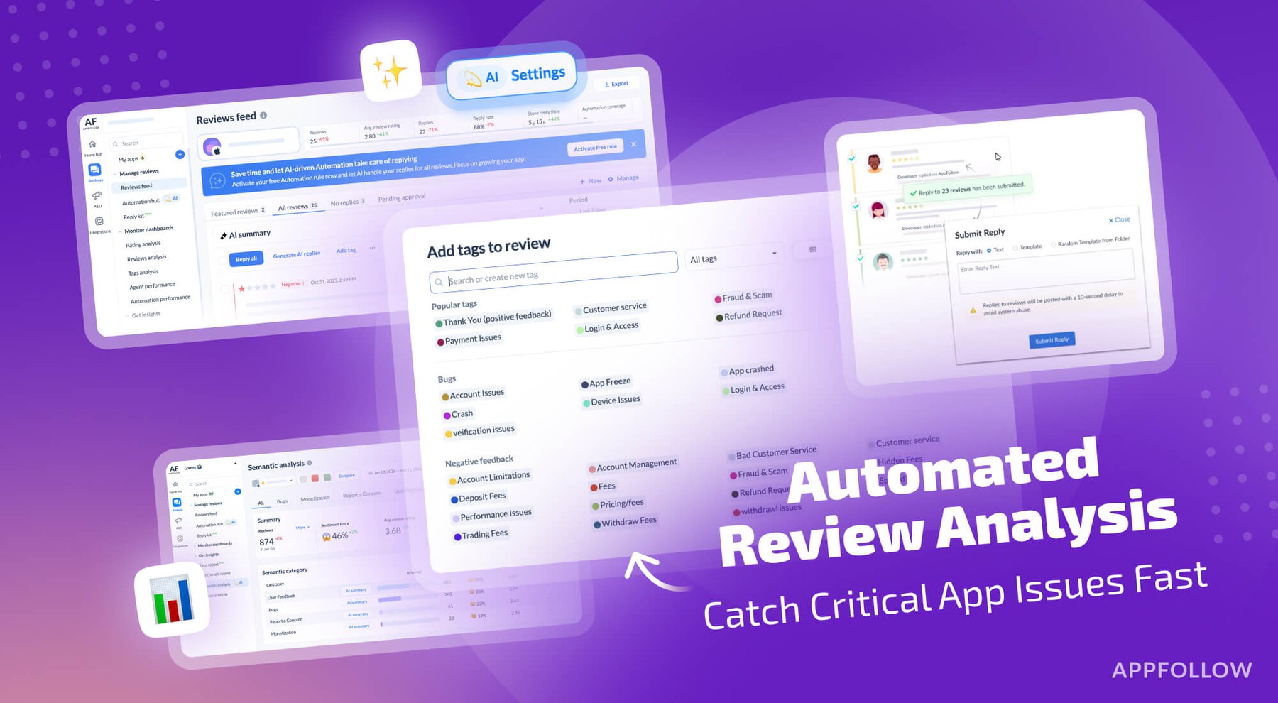
Ratings & Reviews performance provides an overview of what users think of your app. Here are the key metrics to help you identify how your app is rated by users and how successful is your review management strategy.
WHY HUNTER TRACKER?There are a few hunting apps on the market these days, and even less tracking apps. Most are complicated and time consuming. And what happens AFTER you bag that big buck? With these issues in mind, we created Hunter Tracker, the world's easiest hunting and tracking app! It was created for hunters by hunters. The same problems that you’ve faced in the wild, we've faced as well.Working hunters with families don't always have the luxury of sitting in the blind for days at a time. Hunter Tracker lets you know the best times to hunt, the best places to hunt, and the conditions you'll be facing while you're out there. Compass, flashlight, GPS, Maps, Lunar Activity, and Weather Forecasts will give you the edge you need to get the job done!COMPASSCompass image with standard compass needle points, digital readout with the bearing in degrees, alphabetic symbols with compass needle heading.DIGITAL AND MAP GAME TRACKINGSimply find the first sign of the animal's trail and tap the MARK GPS POSITION button. A coordinate will pop up on the screen. Move on to the next blood drop or broken twig and mark it. If you lose the game's trail, just tap one of the coordinates and the GPS will guide you back to it.UNLIMITED HUNTING AREASAdd as many locations as you choose. Hunters should also add the location of their vehicle just in case they get turned around in the woods. When you tap the ADD NEW HUNTING AREA button, a screen with two tabs will appear:"The BY LOCATION tab prompts you to either choose the location you are at or type in an address. Once the GPS coordinates have been determined, type in a descriptive name and save the location.The BY MAP tab allows you to zoom in on a specific area. Once you have found your desired area on the map, simply hold your finger on that area until the scent indicator appears. Then, just type in the descriptive name for that location and tap the SAVE LOCATION button.Tapping a location on the list brings up a menu with four choices:Show location on map will bring up the map of the location. If the scent indicator is not in the precise position of your choosing, just hold your finger on it until it is draggable, then drag it to the exact location. The slider at the bottom of the map can be dragged to display the wind speed and direction, along with the deer activity for any time during the next 5 day period. The Button at the bottom cycles through your choice of Street, Hybrid, or Satellite views.Get directions to location will bring up a screen showing your CURRENT COORDINATES and the DESTINATION COORDINATES. Below that, you will see the DISTANCE TO DESTINATION and BEARING TO DESTINATION. Your CURRENT BEARING will be shown in red. Simply turn toward the destination bearing until both the BEARING TO DESTINATION and the CURRENT BEARING turn green. Then you just walk until the DISTANCE TO DESTINATION reads 0.Delete the location will delete whatever location you tapped on. Delete all locations will delete every location you've saved. It will not affect your saved tracking coordinates, however.UP TO THE MINUTE WEATHER UPDATESThere are three tabs on the weather page:The CURRENT tab displays the current weather in either standard or metric. Notice the SCENT INDICATOR, the same one you'll see on your HUNTING LOCATION page. By tapping the DOWN ARROW in the upper right corner, you can choose which location you'd like the weather to show.The FORECAST tab displays the weather in either standard or metric, depending on what you've chosen on the settings page, over a 5 day period in 3 hour increments.The LUNAR tab displays the 5-day lunar activity in either 12 or 24 hour time format, depending on your settings. Combined together, this data is a great indicator of deer or other game activity and the probability of seeing movement.With all of this in one easy to use app, why not use it?
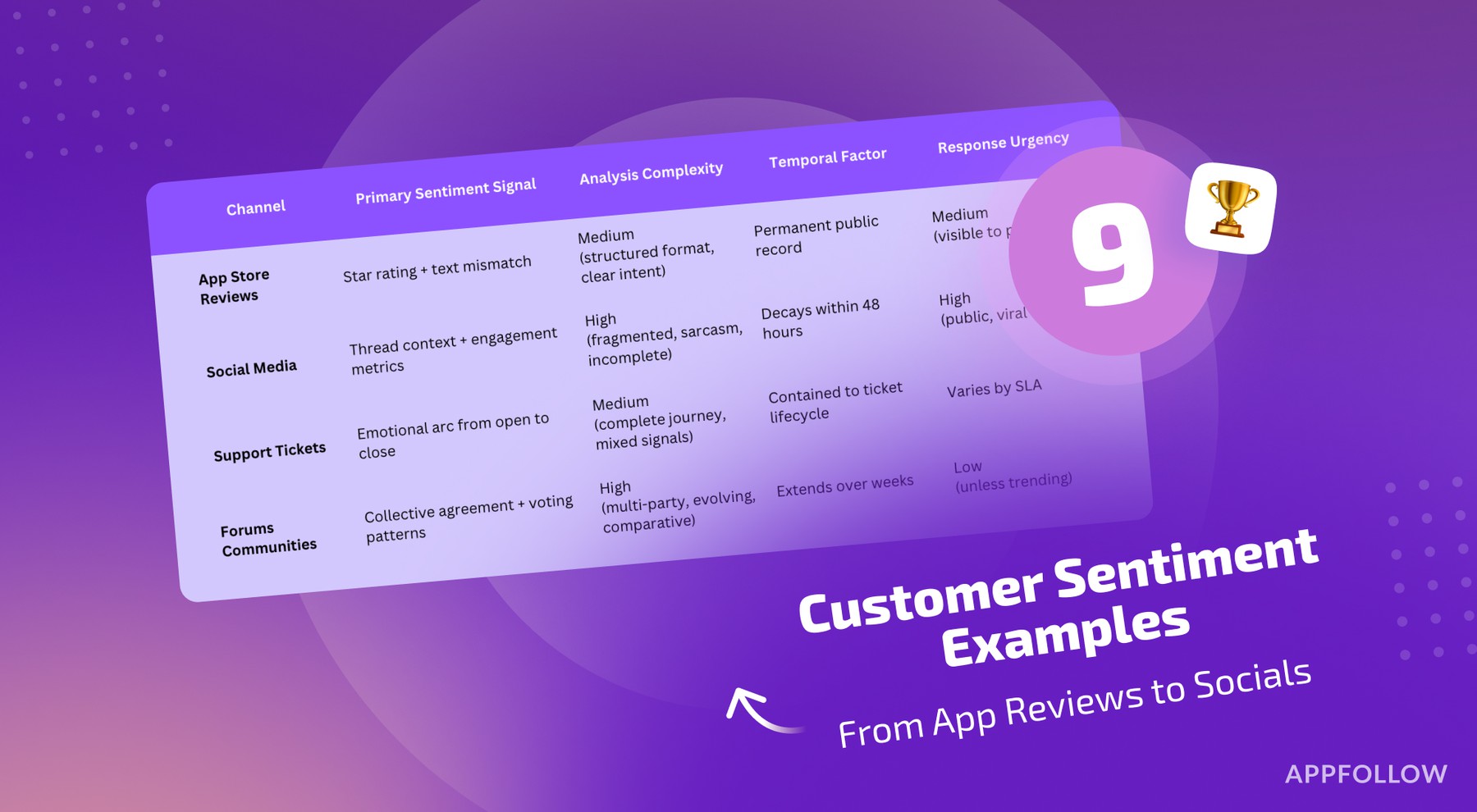
![How to measure customer sentiment for app reviews [7 metrics]](https://cdn.appfollow.io/blog/static/appfollow_1335e02d-b0b3-49f7-9eb6-94171dc7e379.jpg)